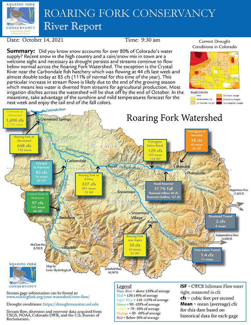
Starting in 2009, every Thursday morning at Roaring Fork Conservancy (RFC) an investigation is underway. It’s not an unsolved cold case, though the subject matter is often cold (at least we hope so!). This is an ongoing investigation to uncover and interpret the ever-changing weekly watershed conditions. What are the snowpack conditions in the watershed? How are the rivers flowing? Are there any drought conditions? What about flooding concerns? These are just a few of the questions that guide the inquiry that becomes the weekly Snowpack and River Report throughout the year. And as always, we look to the experts and their data for responses to these questions.
To begin each report, we look for the basic conditions across the watershed, starting with two key measurements: stream discharge and snow water equivalent (SWE). For discharge data, or stream flows colloquially, we use a network of U.S. Geological Survey (USGS) and Colorado Division of Water Resources (DWR) stream gauges located in rivers across the watershed that measure the cubic feet per second (CFS) of water moving downstream. For SWE data, eight Natural Resources Conservation Service (NRCS) SnoTel stations are our starting point. These sites provide both current measurements and percentages of average, which compare current measurements to their thirty-year average. Once all these numbers are recorded, we have the beginning of a report.
Next, we dig for further data and information to contextualize our report summary. For example, when Ruedi Reservoir releases increase or decrease, we contact Bureau of Reclamation (BOR) to find out why and for how long. When windy weather disperses dust across the watershed, the Colorado Dust-on-Snow Program is the definitive resource to understanding the implications.
When precipitation is lacking and soil is drying, we turn to the Colorado Drought Monitor. By the time a report is finished, multiple science-based resources are engaged to ensure the whole picture is captured. We also strive to add information pertinent to those recreating in the watershed: fishing closures, avalanche conditions, and ice jam release warnings are all elements we include at various times of the year.
All together, we frequent over a dozen resources including USGS, DWR, NRCS, BOR, U.S. Forest Service, Colorado Duston-Snow Program, Colorado Drought Monitor, Western Water Assessment, National Integrated Drought Information System, OpenSnow, National Weather Service, Colorado Parks and Wildlife, Colorado Avalanche Information Center, Colorado River District, Aspen Snowmass ski resorts, Sunlight Mountain Ski Resort, local news organizations, and many others. Each resource provides key expertise to understanding the watershed.
Once all the facts are gathered and relevant resources consulted, we write a succinct summary that provides the most important up-to-date information and translates the science in an understandable way. It’s no easy feat. And by the time the report is finished, we’re already on the lookout for next Thursday.
A good investigation is necessary when current facts are either misunderstood or incomplete. When the River Report began, about 15 years ago, existing snow and river information focused solely on ski or whitewater conditions. We saw the need to dive deeper and provide comprehensive information about the water in the snow and in the river and the relationship between the two. The reports became an instant success, used by river enthusiasts, ski bums and water wonks alike, as the acronyms of SWE and CFS became common language. Currently, this weekly report is emailed to over 555 friends across the state and country, viewed hundreds of times on our social media pages, and published every Friday in The Aspen Times since 2017. If we continue at this pace, we won’t be surprised if some major news networks call to try and emulate our investigative techniques!
The responsibility we have to our rivers is enormous, and while we try not to take ourselves too seriously, we take seriously educating the public to help illuminate the critical importance of water beyond the epic powder day or sweet Class IV rapid. By providing a weekly update every week of the year, we elevate community and visitor knowledge and enhance understanding of persistent drought, each water year’s seasonal fluctuations, and conditions across the watershed amid a changing climate.


 We thank our friends at Alpine Bank for supporting our Snowpack Reports.


