Roaring Fork Conservancy's mission is to "inspire people to explore, value and protect the Roaring Fork Watershed." One way that Roaring Fork Conservancy strives to accomplish this mission is by protecting and preserving critical habitat throughout the watershed. Placing a conservation easement on a piece of property ensures that the land will not be developed. Roaring Fork Conservancy currently holds the following riparian properties:
Blue Creek
Acres: 21.00
Date Acquired: October 31, 2002
Riverfront Protected: 1,410 feet of Roaring Fork River
Owner: Blue Creek Ranch Homeowners Association
Public Access: Limited to trail along river
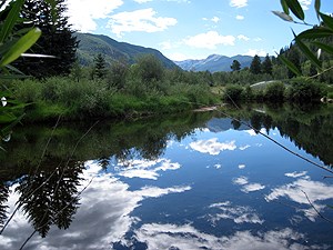
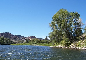
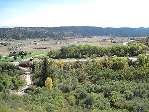
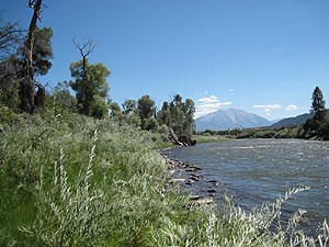
The Blue Creek Easement is located on the bank of the Roaring Fork River, near Catherine Store Bridge. Pictured are some of the towering cottonwoods and ponderosas that make the easement unique. The property offers public fishing access along the river trail and carry-in boat access from a parking lot off County Road 100.
Brooks
Acres: 0.29
Date Acquired: December 31, 2001
Owner: Privately Owned
Public Access: None
Located in the Crystal River Valley, the Brooks Conservation Easement contains a viable aspen stand that connects open space to a deer and elk migration corridor.
Burry
Acres: 8.07
Date Acquired: December 31, 2005
Riverfront Protected: 1,370 feet of Roaring Fork River
Owner: Privately Owned
Public Access: None
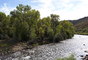
The Burry Conservation Easement protects important riparian habitat along the Roaring Fork River below Carbondale. Stands of narrow-leaf cottonwood provide a canopy for a thriving community of riverside plants, small mammals and over 110 bird species, as well as serving as winter habitat for migrating deer and elk populations.
Cattle Creek Confluence
Acres: 53.60
Date Acquired: February 3, 2000
Riverfront Protected: 6,865 feet of Roaring Fork River (combined with Heron Point Easement) and 1,350 feet of Cattle Creek
Owner: Harvest Roaring Fork
Public Access: None currently
Formerly occupied by the Sanders Ranch, this property continues south from where Cattle Creek joins the Roaring Fork River. A varied landscape of wetlands, upland hillsides, pastures and riparian vegetation serve an equally diverse array of wildlife. The active great blue heron rookery highlights the Cattle Creek Confluence Easement, in addition to mule deer, elk, osprey, bald eagles, trout, mink, beavers, bobcat and even an occasional mountain lion.
Crystal River Confluence
Acres: 6.29
Date Acquired: February 7, 2000
Riverfront Protected: 1,000 feet of Roaring Fork River
Owner: Midland Point Homeowners Association
Public Access: Limited fishing access
Located near the junction of the Crystal and the Roaring Fork Rivers, the Crystal River Confluence Easement consists primarily of wetlands and riparian habitat. Mule deer, bald eagles, great blue heron, and coyotes can be found amongst the gamble oak, Rocky Mountain Juniper and wild rose around this property. In addition to providing critical wildlife habitat, the healthy wetlands associated with this space function to improve water quality and help moderate spring runoff.
Emma Open Space
Acres: 73.40
Date Acquired: June 21, 2000
Riverfront Protected: 2,000 feet of Roaring Fork River
Owner: Pitkin County
Public Access: Limited to Emma and Rio Grande Trails
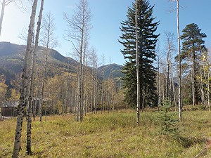
The acquisition of Emma Open Space was a true community effort, requiring the cooperation of several state, county, town and non-profit entities. In addition to protecting critical wildlife habitat, this property also serves both agricultural and recreational activities. The Emma Open Space spans both sides of the Roaring Fork River, linking the wildlife corridors on either side. The riparian and wetland areas along the Roaring Fork River contain unique birch-alder communities that support dozens of species of wildlife. On the hillside, the pinon-juniper and oak-serviceberry communities provide important food seasonally for deer, elk, birds and other small mammals. The popular migration corridor is supplemented by a wildlife underpass, allowing deer and elk to safely avoid a busy Highway 82 at this point along their seasonal journey.
Filoha Meadows
Acres: 50.00
Date Acquired: November 8, 2002
Riverfront Protected: 3,250 feet of Crystal River
Owner: Pitkin County
Public Access: Limited Access from Redstone
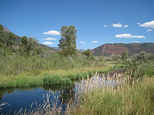
Located on the Crystal River between Redstone and Avalanche Creek, Filoha Meadows encompasses one of the most unique landscapes in the watershed. Filoha, the Ethiopian word for hot water, earned its name from the picturesque hot springs and thermally heated meadows that create an unprecedented plant and wildlife community. In the winter, bighorn sheep bask in the warmth of the meadows, while an endemic population of fireflies flickers over the grasses between rare orchid species through the summer. In recent years, Roaring Fork Conservancy has partnered with Pitkin County Open Space and Trails to provide naturalist guided programs at Filoha Meadows, offering exploration beyond the railroad gate with insights into the natural and human histories of this one-of-a-kind landscape.
Fourmile Creek
Acres: 13.00
Date Acquired: September 7, 2007
Riverfront Protected: 440 feet of Fourmile Creek
Owner: Privately Owned
Public Access: None
In an area where increased development pressures have resulted in disturbed and fragmented riparian habitat, Fourmile Creek Easement provides a refuge of native vegetation for wildlife use and habitat. Mule deer, songbirds, raptors, owls and turkeys are all known to frequent the area. The undisturbed in-stream habitat benefits native trout, macroinvertebrates, American dippers and waterfowl. Additionally, the protection of this space preserves open space and viewsheds crucial to the Fourmile Creek Watershed.
Gerbaz Bridge
Acres: 0.95
Date Acquired: October 9, 2008
Riverfront Protected: 280 feet of Roaring Fork River
Owner: Pitkin County
Public Access: Fishing and boating access; public parking
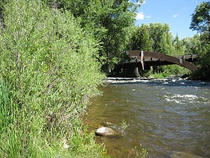
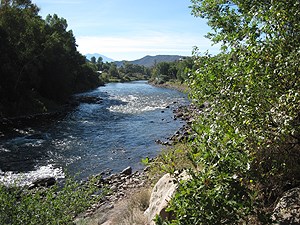
The Gerbaz Bridge Easement is nestled between the Roaring Fork River and the Rio Grand Trail, seven miles south of Basalt. Narrow-leaf cottonwoods provide a shady space for fishing or boat access. As one of many protected properties in the area, Gerbaz Bridge aids in the conservation of wildlife habitat and the scenic viewshed of the Roaring Fork River.
Grange Loadout
Acres: 9.33
Date Acquired: December 4, 2008
Riverfront Protected: 1,250 feet of Crystal River
Owner: Pitkin County
Public Access: Passive fishing access
Located just across the Crystal River from the south end of Filoha Meadows, the Grange Loadout Easement provides an invaluable buffer between the nearby developments of Highway 133 and the Crystal River. Under the towering narrow-leaf cottonwoods and blue spruce, a dense shrub layer provides habitat for the mountain bluebird, northern pocket gopher, a variety of raptor and owl species, short-tailed weasel and red fox among others. Fishing access and a historic cattle chute compliment the picturesque ecology of Grange Loadout.
Grange River
Acres: 13.00
Date Acquired: September 7, 2007
Riverfront Protected: 2,530 feet of Roaring Fork River
Owner: Eagle County & Town of Basalt
Public Access: Fishing access along Two Rivers Road side of easement only
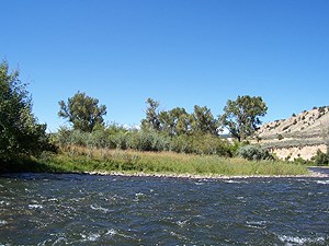
The Grange Ranch Conservation Easement protects prime Roaring Fork River habitat, wetlands and river bank just west of downtown Basalt. The Grange River parcel fills an essential central piece of continuous protected land. With its Gold Medal Trout Waters, lush riparian vegetation and irrigated agricultural plain, this property has recreational, ecological and historical appeal. Home to elk, mule deer and bald eagle in the winter, and a host of bird, active beavers and other small mammals in the summer, the habitat at Grange River is bustling year round. Framed by narrowleaf cottonwoods and river birch, the healthy riparian area serves as a buffer around this vibrant stretch of river.
Heron Point
Acres: 7.11
Date Acquired: December 4, 1998
Riverfront Protected: 6,865 feet of Roaring Fork River (combined with Cattle Creek Confluence easement)
Owner: Ironbridge Homeowners Association
Public Access: None currently
Sandwiched between the Cattle Creek Confluence Easement and the Roaring Fork River, the Heron Point Easement contributes to 1.25 continuous miles of riverside protection. Heron Point serves its namesake by providing critical habitat and nesting sites for Great Blue Heron within the towering cottonwood stands. Bald eagles, woodpeckers and swallows are among the bird species that accompany the great blue heron, while active beavers continue to contribute to a healthy wetland understory.

Park East
Acres: 7.95
Date Acquired: August 30, 1999
Riverfront Protected: 2,120 feet of Roaring Fork River
Owner: Park East Homeowners Association
Public Access: Along paved trail west of easement and via two gravel trails to the river
The Park East Conservation Easement is located in Glenwood Springs along the banks of the lower Roaring Fork River. This protected riparian hillside offers peaceful community river access where the historical township of Cardiff once thrived on coal production. A relic from this bygone era, the adjacent Cardiff Schoolhouse now provides a local gathering place for arts and education.
Powerhouse
Acres: 2.69
Date Acquired: November 20, 2007
Riverfront Protected: 1,040 feet of Crystal River
Owner: Pitkin County
Public Access: None currently
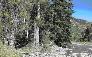
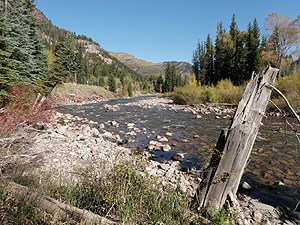
Just 1.5 miles south of Redstone, the Powerhouse Easement spans the Crystal River. The robust riparian vegetation, dominated by narrowleaf cottonwood and blue spruce trees, serves not only as habitat for native wildlife, but also provides significant buffer for high water events. With qualities characteristic of the Crystal River Valley, this easement protects both ecological and historical assets. Alongside the river is the historic Redstone Hydroelectric Power Plant, which operated from the late 1800s through 1950s. Protection of this property contributes to the ecological and historical preservation of the valley.
Silver Lining Ranch
Acres: 2.70
Date Acquired: August 3, 2011
Riverfront Protected: 872 feet of Roaring Fork River
Owner: Privately Owned
Public Access: None currently
Silver Lining Ranch Conservation Easement preserves the ecologically signifcicant weland and riparian communities along the Roaring Fork River above Aspen. Plant communities include beaked sedge, mountain big sage bruch, mountain willow and narrow leafed cottonwood. The property provides wildlife habitat for 20 mammal, 10 reptile, five fish, and 68 bird species.